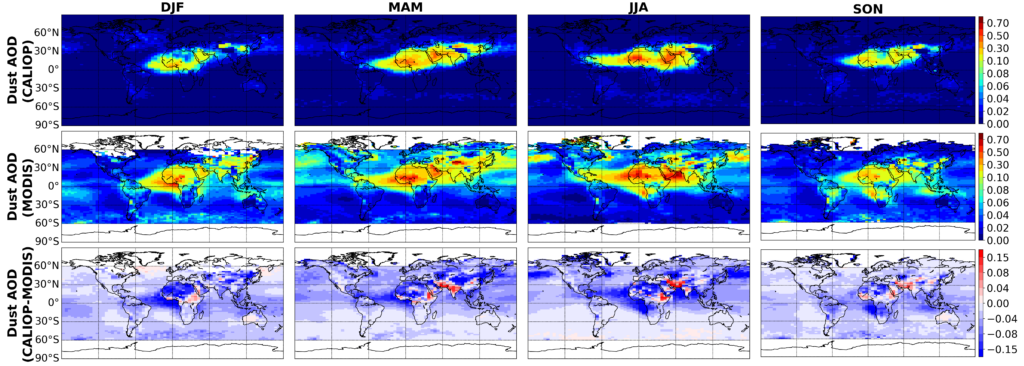
1. Decadal global dust aerosol optical depth and extinction profile climatology based on MODIS and CALIOP [Song et al. 2021]
Link to the data: https://drive.google.com/drive/folders/1aQVupe7govPwR6qmsqUbR4fJQsp1DBCX [last visited 03/09/2022]
In Song et al. (2021) We derived two observation-based global monthly mean dust aerosol optical depth (DAOD) climatological datasets from 2007 to 2019 with a 2 (latitude) x 5 (longitude) degree spatial resolution, one based on CALIOP and the other on MODIS observations. In addition, the CALIOP climatological dataset also includes dust vertical extinction profiles. Dust is distinguished from non-dust aerosols based on particle shape information (e.g., lidar depolarization ratio) for CALIOP based on the method described in Yu et al. (2015), and on dust size and absorption information (e.g., fine-mode fraction, Ångström exponent, and single-scattering albedo) for MODIS (Yu et al 2020, Pu and Ginoux, 2018 ), respectively. The two datasets compare well with the results reported in previous studies and the collocated AERONET coarse mode AOD.
Latest update [March, 2022]: we found/fixed a minor bug in our CALIOP data and reprocessed the data. We also added the year 2020 to our latest dataset V2.
CALIOP dataset V2:
- GlobalClearSkyMeanDustClimatology_CALIOP20072019Monthly.nc
- GlobalClearSkyMeanDustClimatology_CALIOP2020Monthly.nc
- Global clear-sky visible (532 nm) total and dust aerosol extinction profile and AOD derived based on the CALIOP data for year 2007-2020
- Dust extinction profile and AOD are the mean value of the high and low scenarios (see below)
- Spatial resolution: 2 (latitude) x 5 (longitude) ~ Global
- Temporal resolution: Monthly mean ~2007-2020
- GlobalClearSkyHighDustClimatology_CALIOP20072019Monthly.nc
- GlobalClearSkyHighDustClimatology_CALIOP2020Monthly.nc
- Global clear-sky dust aerosol extinction profile and AOD based on high scenario estimation
- GlobalClearSkyLowDustClimatology_CALIOP20072019Monthly.nc
- GlobalClearSkyLowDustClimatology_CALIOP2020Monthly.nc
- Global clear-sky dust aerosol extinction profile and AOD based on low scenario estimation
MODIS dataset:
- AquaModis_Ocean_ncountGE10_Land_AOD_20032019_Monthly_1degX1deg.nc
- Global dust AOD climatology from 2003 to 2019 based on the combination of dust AOD over ocean developed by Yu et al. (2015,2020) and dust AOD over land developed by Pu and Ginoux (2018).
- Spatial resolution: 1 (latitude) x 1 (longitude) ~ Global
- Temporal resolution: Monthly mean ~ 2003-2019
- AuqaModis_Ocean_ncountGE10_Land_AOD_20032019_Monthly_5degX2deg.nc
- Same as above, except for a coarser spatial resolution
- Spatial resolution: 2 (latitude) x 5 (longitude) ~ Global
Please report any issue or bug to: Zhibo Zhang Email: zzbatmos@umbc.edu

References:
Yu, H. B., M. Chin, H. S. Bian, T. L. Yuan, J. M. Prospero, A. H. Omar, L. A. Remer, D. M. Winker, Y. K. Yang, Y. Zhang, and Z. B. Zhang. 2015. “Quantification of Trans-Atlantic Dust Transport from Seven-Year (2007-2013) Record of CALIPSO Lidar Measurements.” Remote Sensing of Environment 159:232–49.
Yu, Hongbin, Yang Yang, Hailong Wang, Qian Tan, Mian Chin, Robert Levy, Lorraine Remer, Steven Smith, Tianle Yuan, and Yingxi Shi. 2020. “Interannual Variability and Trends of Combustion Aerosol and Dust in Major Continental Outflows Revealed by MODIS Retrievals and CAM5 Simulations During 2003–2017.” Atmospheric Chemistry and Physics Discussions 1–38.
Pu, Bing and Paul Ginoux. 2018. “How Reliable Are CMIP5 Models in Simulating Dust Optical Depth?” Atmospheric Chemistry and Physics 18(16):12491–510