The “traditional” satellite sensors usually measure the intensity (i.e., radiometer) and/or spectral variation (i.e., spectrometer) of light. In comparison, a polarimeter can measure not only the spectral intensity, but also the polarization direction of light and therefore contain more information for remote sensing. Another research direction I have been exploring since around 2014 is the remote sensing of cloud and aerosol properties from satellite-based polarimetric measurements. Multi-directional, multi-wavelength, high-accuracy polarization imager has been identified by the National Research Council’s Earth Sciences Decadal Survey as a key component of NASA’s next generation Earth missions.
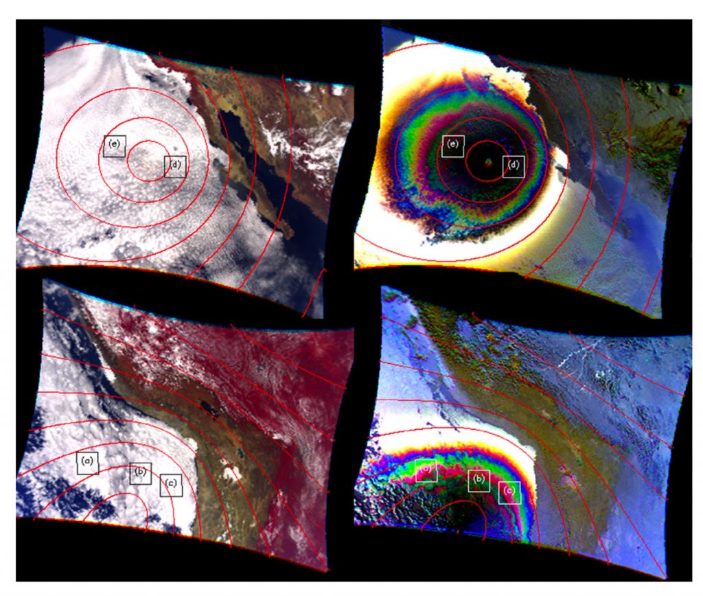
Our research along this direction aims to utilize the unique multi-directional, multi-wavelength polarimetric cloud observations to better retrieve cloud properties, in particular to overcome some longstanding issues in radiometric cloud retrievals caused by cloud heterogeneity such as 3-D radiative effects. It is worth mentioning that most of research work in this direction has been carried out by my graduate student under my supervision. My first graduate student, Daniel Miller developed a satellite cloud retrieval simulator based on the combination of polarized radiative transfer model and large-eddy simulation model to simulate the polarimetric, multi-angular, and multi-spectral measurements from the synthetic cloud fields [Miller et al., 2016]. Using this framework, he later led a comparison study to understand how sub-pixel scale cloud inhomogeneity affect the radiometric- and polarimetric-based cloud property retrievals differently [Miller et al., 2018]. These novel research by Dan had helped him won the prestigious NASA Earth System Earth and Space Science Fellowship (NESSF) and later the NASA’s Postdoctoral Program (NPP). Over the last few years, another graduate student of mine, Chamara Rajapakshe, significantly extended Dan’s research. He greatly improved the capability of the satellite cloud retrieval simulator by coupling it with a powerful 3-D vector radiative transfer model developed by our group [Wang et al., 2017; 2019]. In Rajapakshe and Zhang [2020], we used this improved simulator to explore the possibility of utilizing multi-directional polarimetric observations to detect and correct the retrieval bias caused by 3-D radiative effects. The result is very encouraging, and we are now working with collaborators to apply this novel method in real observations. At this moment, Rajapakshe and I are working on two more papers that discuss the different impacts of 3-D radiative effects on radiometric vs. polarimetric cloud property retrievals. It is worth special mentioning that NASA’s Plankton, Aerosol, Cloud and ocean Ecosystem (PACE) mission, which will be launched in 2022-2023 timeframe, will be equipped by two polarimeters (actually one named HARP will be from UMBC’s Dr. Vanderlei Martins’ team). In summary, our main contribution in this area is to develop a state-of-the-art polarimetric cloud property retrieval simulator which has enabled us to reveal some great potentials, as well as weaknesses, of polarimetric observations for cloud remote sensing in comparison with the “traditional” radiometric methods. Recently we become a science team member of the PACE mission. Together with our collaborators, we will be responsible for developing a novel polarimetric-based cloud retrieval product that will be used by the PACE mission and the broad public for many years to come.